26 August 2026 | 10 Bhadra 2083
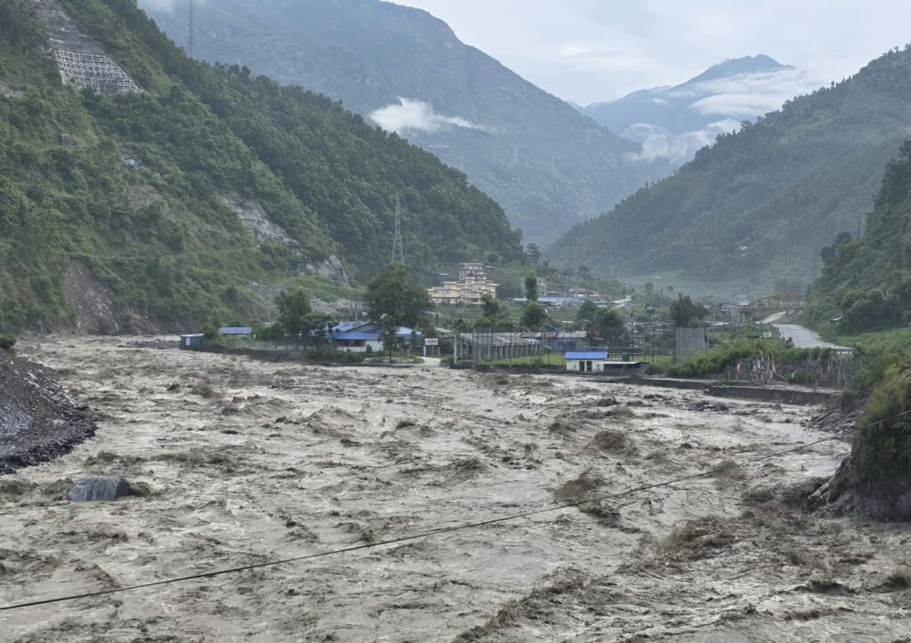
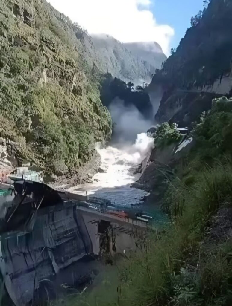
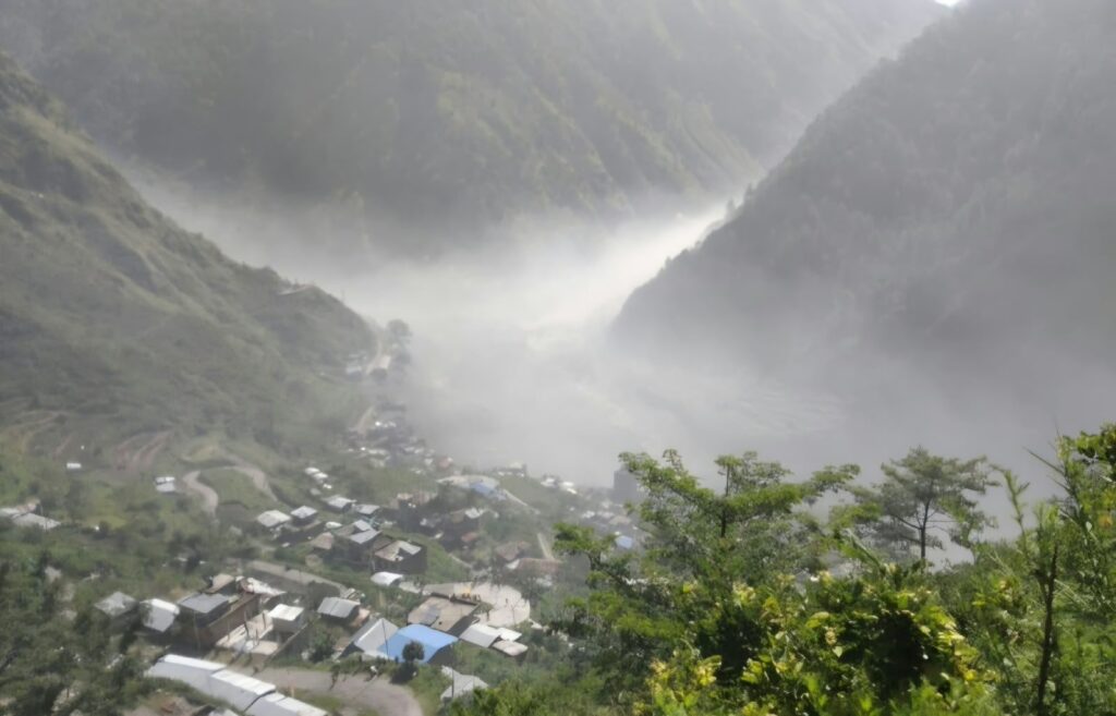
The devastating flash flood that struck the Bhotekoshi–Trishuli river system in Rasuwa on 26 August 2026 has once again left Nepal in deep shock and mourning.
As this article is being prepared, official reports confirm significant loss of life, while many citizens, security personnel, workers and travellers remain missing or unaccounted for. Search, rescue and verification efforts are still ongoing, and the casualty figures may continue to change.
I extend my heartfelt condolences to the families who have lost their loved ones. I also wish a speedy recovery to those who have been injured and sincerely hope that those still missing are found safely.
My deepest respect goes to the personnel of the Nepal Army, Armed Police Force, Nepal Police, medical teams, local governments, volunteers and all other agencies working under extremely difficult conditions to carry out search, rescue, medical assistance, relief and emergency coordination.
At this critical moment, the immediate priorities must remain clear:
Protect human life. Search for the missing. Treat the injured. Evacuate communities still at risk. And ensure that affected families receive food, safe drinking water, medicines, temporary shelter and other essential assistance without delay.
However, once the immediate emergency is brought under control, this tragedy must also compel us to confront a much broader national question:
How long can Nepal continue treating recurring disasters as unexpected natural events?
Nepal is, by its geography and geology, a multi-hazard country.
The Terai faces floods, inundation and river erosion.
The Chure and foothill regions are vulnerable to flash floods, erosion and sediment movement.
The middle hills repeatedly experience landslides, debris flows and slope instability.
The high Himalayas face avalanches, glacial lake outburst floods, ice-rock avalanches and other rapidly evolving cryospheric hazards.
Our growing cities are simultaneously exposed to earthquakes, fires, urban flooding, drainage failure and unsafe construction.
When serious disasters affect one part of the country almost every year, these events can no longer be treated purely as unforeseen emergencies.
They represent the continuing manifestation of known and, in many cases, already identifiable national risks.
According to records of Nepal’s National Disaster Risk Reduction and Management Authority, 32,375 disaster events were recorded between 2018 and mid-2024.
That scale of exposure sends a very clear message:
For Nepal, disaster risk management cannot remain an occasional emergency-response function. It must become an integral part of development planning, land-use policy, settlement planning, infrastructure, education, health, energy, tourism, environmental management and national security.
Understanding the Bhotekoshi Event Scientifically
The precise scientific cause of the 26 August 2026 Bhotekoshi flood should be determined only after detailed investigation.
Initial scientific assessments are examining possibilities including an ice-rock avalanche, temporary blockage of an upstream watercourse, and a sudden release of water, sediment and rock debris.
It is therefore important not to attribute the disaster conclusively to a single cause until the scientific investigation is complete.
What makes the situation particularly concerning, however, is that this is not the first major transboundary flood event affecting the same corridor.
On 8 July 2025, a destructive flood in the Rasuwa–Kerung corridor was linked by Nepalese authorities to the sudden discharge of a supraglacial lake in the Purepu Glacier area of Tibet.
Another major event affecting the same river system only a little over a year later should be treated as more than an isolated warning.
It should prompt a serious review of Nepal’s approach to disaster preparedness, transboundary risk monitoring, land use and infrastructure development.
There is also an important scientific distinction that should guide public policy.
Floods, earthquakes, landslides, avalanches and glacial events may be natural hazards.
But the scale at which a hazard becomes a human disaster is heavily influenced by:
- exposure,
- vulnerability,
- settlement patterns,
- infrastructure design,
- land-use decisions,
- preparedness,
- early warning, and
- institutional capacity.
In other words:
We may not be able to prevent natural hazards, but we can prevent many of them from becoming large-scale human catastrophes.
Nepal now needs to move beyond a predominantly reactive disaster-management system and establish a genuinely risk-informed, prevention-oriented and science-based model of disaster governance.
I believe the following areas require urgent and sustained national attention.
1. Risk Maps Must Become Legally Relevant Planning Tools
Nepal should continuously update multi-hazard mapping for:
- floods and floodplains,
- landslides,
- debris flows,
- earthquakes,
- glacial lake outburst floods,
- avalanches,
- wildfires, and
- urban flooding.
These maps should be available through a publicly accessible digital platform down to the municipal and community level.
More importantly, risk maps should not remain technical documents stored in government offices.
They must directly influence decisions on:
- land development,
- building permits,
- infrastructure investment,
- settlement expansion,
- school and hospital locations, and
- industrial and commercial development.
A risk map that does not influence development decisions has limited practical value.
2. Nepal Must Prevent Further Population Concentration in High-Risk Areas
Where high-risk areas have already been identified, government policy should actively prevent further concentration of population and infrastructure.
New plotting, housing colonies, hotels, schools, hospitals, markets or major structures should not be routinely approved within:
- active floodways,
- unstable slopes,
- known landslide zones,
- potential debris-flow corridors,
- high-risk GLOF pathways, and
- other scientifically identified danger zones.
Nepal should consider a national zoning framework under which areas are classified, for example, as:
Red Zones – where new development is prohibited;
Conditional Development Zones – where development is permitted only after specific engineering and risk-mitigation requirements are met; and
Lower-Risk Development Zones – where planned settlement and infrastructure development can be encouraged.
Government itself must also avoid unintentionally creating future disasters by extending roads, utilities and public facilities in ways that encourage uncontrolled settlement expansion into high-risk locations.
3. Building Permits and Land Development Must Include Hazard Clearance
In hazard-prone areas, municipal building approval cannot be limited to architectural drawings, setbacks and conventional structural requirements.
Approvals should also consider:
- geotechnical conditions,
- slope stability,
- drainage capacity,
- historical flood levels,
- projected extreme-flood scenarios,
- debris-flow exposure,
- evacuation access, and
- accessibility for emergency services.
Where risk maps clearly identify serious hazards, there must also be accountability for authorising inappropriate construction or land subdivision.
4. Known High-Risk Settlements Should Not Be Allowed to Expand Indefinitely
Nepal already possesses considerable information about many vulnerable communities.
Yet in numerous locations, houses, businesses and infrastructure continue to expand even after the risks have been identified.
That creates a dangerous cycle.
One house becomes a cluster.
A cluster becomes a settlement.
A settlement becomes a market centre.
And once a large population and economic activity become established, relocation becomes socially, economically and politically much more difficult.
This is why:
Preventing the creation of new risk is more practical, humane and cost-effective than repeatedly financing disaster response and reconstruction.
5. Existing High-Risk Communities Need Planned and Dignified Relocation Options
For communities that have lived for generations beside rivers, unstable slopes or other hazardous areas, simply telling people to “move somewhere safer” is neither realistic nor fair.
Where relocation is scientifically justified, government should establish structured programmes incorporating:
- transparent risk assessment,
- fair compensation,
- safe housing,
- livelihood opportunities,
- schools,
- healthcare,
- drinking water,
- transportation, and
- access to economic opportunities.
Relocation must not mean merely moving houses.
It must protect both life and livelihood.
Voluntary, planned and properly supported relocation should become part of Nepal’s long-term disaster-risk strategy.
6. Infrastructure Must Be Designed for Tomorrow’s Risks, Not Yesterday’s Climate
Roads, bridges, hydropower facilities, transmission lines, dry ports, customs facilities, drinking-water systems and other critical infrastructure should no longer be designed solely around historical averages.
Engineering standards should incorporate scenarios involving:
- extreme floods,
- glacial lake outburst floods,
- debris flows,
- landslide-dam failures,
- seismic events,
- sediment loads, and
- changing climatic conditions.
If a bridge is washed away and reconstructed at exactly the same elevation, with the same design and without reassessing the hazard, that is not genuine resilience.
Build Back Better should mean that reconstruction addresses the cause of failure and incorporates future risk into the new design.
7. Critical Facilities Should Be Located Outside High-Risk Zones
Hospitals, schools, security facilities, emergency operation centres, fuel depots, telecommunications hubs, data facilities, food warehouses and drinking-water infrastructure should, wherever possible, be located outside major hazard zones.
Existing critical facilities in vulnerable areas should undergo periodic:
- risk assessments,
- structural and resilience audits,
- retrofitting, and
- relocation studies where necessary.
A hospital or emergency centre that becomes inaccessible during a disaster cannot perform the function for which it was created.
8. Early Warning Must Reach the Last Person at Risk
Installing upstream sensors, weather stations, satellite monitoring or radar systems is only one part of an early-warning system.
A truly effective system must transmit warnings through the full chain:
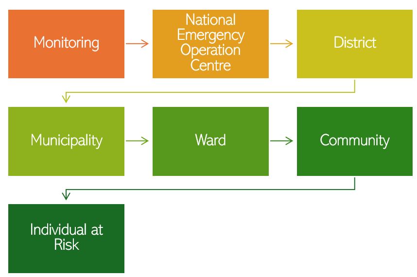
And it must do so within minutes when necessary.
Nepal should integrate multiple communication channels, including:
- Cell Broadcast and SMS,
- sirens,
- FM radio,
- VHF communication,
- satellite systems,
- local emergency networks, and
- trained community volunteers.
Redundancy is essential because one communication system may fail during a major disaster.
People must also know what to do once an alert is received.
Every high-risk settlement should therefore have:
- predetermined evacuation routes,
- designated safe areas,
- emergency shelters, and
- regular evacuation drills.
A warning without an evacuation plan is incomplete preparedness.
9. Nepal and China Need Institutionalised Real-Time Cooperation on Transboundary Himalayan Risks
The risks associated with the Bhotekoshi river system do not begin at Nepal’s international border.
Upstream changes in Tibet involving:
- glaciers,
- glacial lakes,
- landslides,
- river blockages,
- seismic activity,
- rainfall, and
- river levels
can potentially affect communities and infrastructure downstream in Nepal.
Nepal therefore needs a stronger formal mechanism for obtaining real-time or near-real-time upstream risk information.
This should not be framed as a matter of blame.
It should be approached as:
A shared scientific and humanitarian responsibility to protect lives, infrastructure and communities on both sides of the border.
Cross-border monitoring, automatic alerts, data-sharing protocols and direct institutional communication between relevant agencies could provide precious additional minutes or hours for downstream evacuation.
In flash-flood situations, even a few minutes can save lives.
10. Local Governments Must Become Genuine First Responders
In many disasters, local government and local communities are the first to face the emergency.
Yet many municipalities still lack sufficient specialised equipment, trained personnel and emergency resources.
High-risk municipalities should maintain pre-positioned capacity including:
- trained search-and-rescue teams,
- ropes and rescue equipment,
- boats where appropriate,
- emergency medical supplies,
- satellite phones,
- portable power systems,
- temporary shelter materials,
- emergency food and water stocks, and
- basic engineering equipment.
Nepal cannot rely on helicopters and specialist teams travelling from Kathmandu as the primary response mechanism for every major emergency.
National agencies will always remain essential, but strong local capacity saves critical time.
11. Major Development Projects Should Include Disaster Risk Impact Assessment
Infrastructure development can sometimes create new risks while solving another problem.
Road construction, hydropower projects, quarrying, river extraction, hill cutting and uncontrolled urban expansion can affect:
- slope stability,
- drainage,
- sediment movement,
- river morphology,
- downstream communities, and
evacuation routes.
For major developments in hazard-prone areas, Nepal should consider introducing a formal Disaster Risk Impact Assessment, alongside existing environmental and engineering requirements.
Development should demonstrate not only economic viability, but also that it does not unreasonably increase disaster risk for surrounding communities.
12. Mountain Road Construction Requires Stronger Geotechnical Discipline
Road development should not be measured only by kilometres of track opened or annual budgets spent.
Poorly engineered hill roads can significantly increase landslide and debris-flow risk.
Road development in mountainous areas should systematically address:
- geotechnical conditions,
- slope cutting,
- drainage,
- spoil disposal,
- retaining structures,
- bio-engineering,
- erosion control, and
- long-term maintenance.
New projects should undergo proper geotechnical assessment, while vulnerable existing corridors should be subject to independent safety and resilience audits.
13. Every Major Disaster Should Be Followed by Independent Forensic Investigation
After a major disaster, collecting statistics on deaths, missing persons and infrastructure losses is not enough.
Nepal should systematically investigate questions such as:
What exactly happened?
Was the hazard already known?
Was there sufficient warning?
Where did the warning chain fail?
Why did particular structures collapse or wash away?
Could communities have been evacuated earlier?
Were development approvals consistent with known risks?
What should change before the next event?
Each major disaster should be followed by an independent, multidisciplinary scientific investigation.
The findings should be made public.
More importantly, the recommendations should be connected directly to future:
- national and local budgets,
- land-use decisions,
- infrastructure standards,
- building approvals, and
- emergency preparedness programmes.
Otherwise, the same lessons will continue to be rediscovered after every tragedy.
From Disaster Response to a National Resilience Agenda
Citizens also have responsibilities.
We should not normalise the occupation of natural floodways, blockage of drainage systems, unsafe hillside construction or disregard for evacuation warnings.
But the principal responsibility for managing systemic risk lies with the state.
Government has the legal and institutional authority to:
- inform citizens about risk,
- regulate land use,
- control unsafe construction,
- establish infrastructure standards,
- provide early warning,
- coordinate emergency response, and
- create safer alternatives for vulnerable communities.
Nepal’s measure of disaster preparedness therefore cannot remain:
“How quickly did we distribute relief after the disaster?”
The more important question is:
“How many lives did we prepare to save before the disaster occurred?”
Nepal should progressively establish:
- a Multi-Hazard Risk Profile for every local government,
- an Evacuation and Emergency Response Plan for every high-risk settlement,
- a Resilience Audit for critical infrastructure, and
- a Real-Time Early Warning Architecture for every major river basin.
This cannot be treated as a project for a single financial year or one political term.
It should become part of a 20–30 year National Resilience Agenda, implemented consistently by federal, provincial and local governments.
Development cannot simply mean extending a road and then allowing uncontrolled settlement to grow around it.
It cannot mean expanding markets along river corridors without understanding flood risk.
And it cannot mean constructing more concrete structures while ignoring geology, hydrology and evacuation capacity.
True development means creating safer communities, safer infrastructure and a safer future for citizens.
We cannot defeat nature.
But through science, technology, planning, discipline, preparedness and responsible governance, we can prevent many natural hazards from becoming large-scale human catastrophes.
Rebuilding the same type of structure, in the same high-risk location, after every disaster is not meaningful reconstruction.
Real reconstruction means understanding the risk, building in safer locations, applying safer engineering, strengthening early-warning systems and making responsible land-use decisions.
On 26 August 2026, as Nepal mourns the lives lost in the Bhotekoshi disaster, may we also make a long-term national commitment:
Let us not continue paying the same human price for risks that have already been identified.
My deepest condolences to all those who have lost their loved ones.
I wish strength to the bereaved families, a speedy recovery to the injured, and the safe return of those who remain missing.
May this tragedy become a turning point towards a safer, scientifically informed, better-prepared and more disaster-resilient Nepal.